Water and sewer design: Data export
This section describes how you can create stakeout data for a water and sewer facility designed with line definition data.
Transfer to application layer
The program has no direct export to field from line definition data. This means that you must transfer the stakeout basis for manholes and pipes to the application layer. From the application layer you can export to many different external formats and measurement books.
You use the command Copy geometry from command list to clipboard to transfer data from line definition data to the application layer.
The following stakeout data is copied from the model:
- Center manhole at lowest pipe level
- Center manhole cover for manholes with eccentric cone
- Vertical stakeout line from center bottom inside to center top
- Stakeout lines going from center manhole to center manhole (corrected for manhole dimension)
- Points for bends
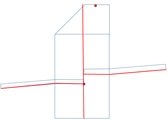
Illustration of stakeout data that is copied
Note
For simple design with manhole groups, the manholes in a manhole group will get the same coordinates in plan view.
Procedure
- Select line definition data, Chaindata (
*.sfi), in the screen - Choose Copy geometry from command list to clipboard on the toolbar
- Select water and sewer objects, check Copy as 3D objects and click OK
- Right-click on the layer where the data should be pasted
- Choose Paste objects and click OK in the message
IFC export of ChainData
The IFC export of ChainData has been improved to provide a more structured model. Objects are now divided by type, attributes are placed in separate Property Sets (Psets), and objects are named automatically.
Object types
ChainData of the type water, storm water, wastewater and pump pipeline is exported as:
IfcFlowTerminalfor manholes.IfcFlowSegmentfor pipes.
Manhole- and pipe-related data fields, for example dimensions, are placed in separate Psets.
ChainData of other types is exported as:
IfcGeographicElement.
For these objects, all data fields are placed in separate Psets.
Naming of objects
The following rules are used when exporting:
- Point objects: the
idfield is used as the name, for exampleO5. - Pipes: pipe type and dimension are used as the name, for example
OV 150. - Object type: the data type description is used as
Object Type, for exampleOvervanndata.
Group structure
Exported objects are linked to a group based on the SFI file name.
Limitations
- GUIDs are not stored. New GUIDs are generated at each export.
- Field names are not remapped. IFC attributes use the same field names as in SFI.
- Pset names can be specified at export, but one common name is used for all three object types.